Having completed a rather large walk this summer (see: LEJOG final day) I took a brief hiatus from my blog, but not walking. I’ve already been on a couple of Rockhopper trips since landing back in the real world; Cheddar and the Brecon Beacons, but what with moving house and starting a new job I didn’t find the time to write up the notes. But now it’s 2018, so a new year and a new motto; “to upload blog reports after each trip”.
Every New Year, the Rockhoppers peel themselves out of their respective Christmas armchairs, arouse themselves from their turkey stupors and head to Scotland to work off the extra mince pies. Crianlarich was this years destination.
Day 1 – 28th Dec 2017 – Grasmere
Peaks – Stone Arthur, Great Rigg, Fairfield
Companions – Rob, Ellen, Christopher
Length (mi) – 6.5
Ascent (m) – 1102
Pubs – Traveller’s Rest
A fully laden car-load of us arranged to travel up via Grasmere and so after stocking up at the local Booths we checked into the YHA. First thing in the morning we re-packed the car ‘tetris-style’ and parked up on the main road. There was an air of excitement as we set off in the direction of the snow on the tops of the fells. It was a stiff climb up out of the valley and onto Stone Arthur but once up there it was the views what took my breath away not the effort of heaving myself up. Crisp white snow, blue sky with fluffy white clouds, and the sun bouncing off the ribbon-like rivers and sprawling lakes.

We had a brief attempt at a snowball fight and then continued up onto Great Rigg where we met the hoards coming from Heron Pike – the more orthodox way to reach Fairfield. We hunkered down in the shelter for a quick lunch and then started to descend to Grisedale Hause. The start of the path was fine but as it got steeper and rockier and the snow had been compacted by those coming up, it was too icy. Crampons on and walking like John Wayne we negotiated the rest of the steepish descent.

Once we were virtually at the bottom and after a few slips (mostly by Ellen), we accidentally took a slightly wrong turn that meant we had to walk past a pub to get to the car. Before long we were supping beverages in the warmth of the pub and looking forward to the next part of the trip. If this was the hors d’oeuvre I was very much looking forward to the main course. Crianlarich here we come!
Day 2 – 29th Dec 2017 – Inverarnan
Peaks – Beinn Chabhair
Companions – Rob, Ellen, Pete, Johnski, Dave, Alison, Bruce, Rachel, Daniel, Rachel and Florrie
Length (mi) – 9
Ascent (m) – 1107
Pubs – Drover’s Arms
With poor weather forecast a large group of us decide to head to Beinn Chabhair where we think we’ll be sheltered for most of the day. It’s an out and back trip, not my favourite, but around here the circuits are very big days that require good weather and/or long days. Neither of which we have today. It was touch and go as to whether all the cars would get out of the icy hostel car park, or along the road (we pass an incident where a car has left the road and lay resting in the ditch, there was already plenty of assistance on scene so we don’t sop). Eventually we gather at the Drover’s Inn and set off through the Beinglas campsite. It looks very different to when I stayed here in August whilst I was on the West Highland Way. Back then it was a hive of activity, absolutely crammed full of campers, hikers and music streaming out of tents/mini-marquees. Today it is deserted, snow covered and the contrast is a bit eerie.
We slip and slide up the side of Ben Glas Burn, soon reaching the plateau with a substantial track and seek out the lochan at the end of which we’ll turn away up and away from it. On the plateau we try to avoid the bogs which are disguised under the snow but a couple of us unintentionally find them. I myself experience an unpleasant trip into a bog. I’m following about five other people in single file along the path when my left foot somehow finds a hole about a foot deep. All of a sudden I’m sat on the ground trying to wrench my foot out which I fail to do. Someone reaches over and yanks my leg releasing my foot from the cold, wet quagmire and in my haste to get up off the ground I swivel and inadvertently plunge my right foot into the cold depths. D’oh! My boots and gaiters do their job and keep most of the water at bay.

We weave our way up steep gullies filled with snow about knee deep, and the going is slow. It’s like walking up a very unstable sand dune; the soft powdery snow gives way to uneven tussocky ground and sometimes ice underneath. Although we can’t see the top, we know we’ve reached the ridgeline and that the summit is nearby. The wind funnels across the mini-col bringing the wind chill down significantly (the forecast was for -10 to -15’C on the tops) so we don’t hang around for long as time is running out. We quickly strike out for the top, reach it and then turn around to retrace our steps.
Going down is far easier, the snow feels soft and forgiving, although we all know that hard rock shaped objects lurk beneath the pristine coating. A couple of gullies are ripe for bum-sliding which a few of us enjoy. On one occasion, I was about halfway down and the congestion at the bottom still hadn’t cleared, I was picking up pace and then a deep trench on the left comes into view. I try to hit the brakes and steer myself right but I become unstable and roll on to my right. My right shin/knee then finds one of the buried rocks and I tumble in the snow. I get up, luckily it’s not serious but it was a hefty clunk and my knee is sore. I limp on down, it soon eases and within what feels like no time at all, we’re back at the lochan (I managed to avoid the hole I found on the way up, unfortunately someone else found it).
Back at the track, the group divides, some head back down the steep burn-side path, some take the track. I opt for the track as the walking is easier on my sore knee, and then proceed to slip on the ice and bruise my other knee. Despite this, my pace quickens as I can almost taste the local ale and smell the wood smoke. It’s an eccentric pub, stuffed with taxidermy at every turn and I dine on a burger with haggis, scrummy!
A great day out and my first winter munro – a baptism of snow and ice, followed by boots drying by the fire.
Day 3 – 30th Dec 2017 – Tyndrum
Peaks – Sron nan Colan, Meall Odhar
Companions – Rob
Length (mi) – 7
Ascent (m) – 662
Pubs – Real Food Café
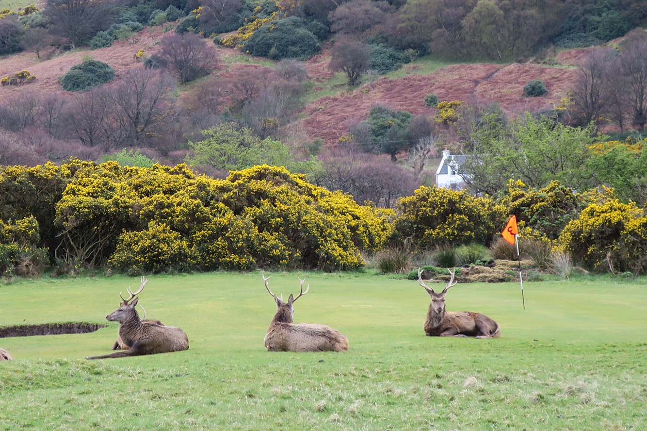
After yesterday I’m up for a slightly shorter day, as is Rob, so we head to the cafe in Tyndrum for breakfast – I decide that I’ve not had enough of the Scottish meats so I go for the full Scottish breakfast with sausages, bacon, black pudding, lorne sausage, plus potato cake, beans and mushrooms. Full of breakfast we head out across the railway line, initially contour around the base of the hill until we head straight up the side. There are lots of deer tracks crossing the path but no sign of any deer, or any other wildlife for that matter, I think it’s too cold for most things. Low down there is a distinct path but we lose it under the snow so we head off-piste but generally head to our right as there are disused mine shafts to our left. There are occasional breaks in the cloud that allow us to view the base of the valley from the hillside. At the top we spot a partridge and the way ahead is laid out by old posts of a border fence.
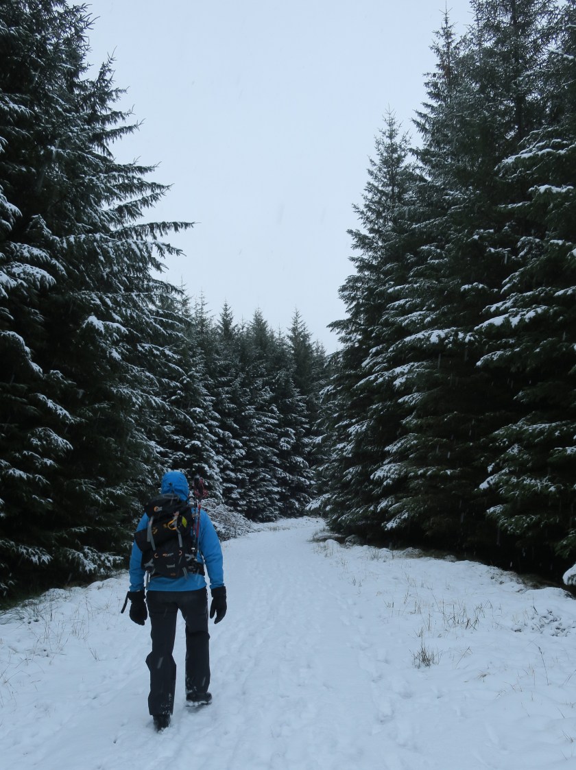
We wander around this mini-ridge and are soon atop Meall Odhar where we stop for a quick bite and a hot toddy – I remembered to bring my hip flask with me today and discover that lemon and ginger tea with whiskey is delicious! We look down on the forest below and there is no obvious route so we meander through the trees – it’s a proper winter wonderland – and there are deer tracks aplenty. We pause to make a snowman, the classic way, by rolling 2 balls of snow down the hill, furnish him with twigs for arms and fern tips for eyes and mouth. He looks a bit like E.T. crossed with No.5 from Short Circuit!

We continue down and just before reaching the edge of the forest a deer scampers off through the trees just a few metres away. Below the trees a large new deer fence (with no stile or gate to be seen miles) is overcome and we meet a track that leads up the valley to Ben Lui. No time for that today, so we turn down the valley, returning into the forest and to the level crossing at Tyndrum back to the cafe!
New Year’s Eve
Unbeknownst to me I barely sleep the night before and since Storm Dylan is forecast to pass over today I opt to spend a day in the hostel along with half a dozen others. I felt very snug and smug staring out at the rain lashing against the windows and the wind swaying the trees. I know I’d rather be sat by the fire reading a book today and looking after Fury the dog, than being out on the hill. In the afternoon it’s time to starting peeling potatoes, turnips and apples in order to serve up haggis, neeps, tatties with gravy and apple crumble for 35 hungry ‘hoppers – a recent new year’s eve tradition. After dinner, a few fireworks, drinks and games we wander down to the local pub to see in 2018. Most of us are tucked up in bed by 1am in order to get up and head back out on the hill the following day.
Day 4 – 1st Jan 2018 – Crianlarich
Peaks – Ben More
Companions – Florrie, Ellen (& Rob sort of)
Length (mi) – 7.3
Ascent (m) – 1146
Pubs – None
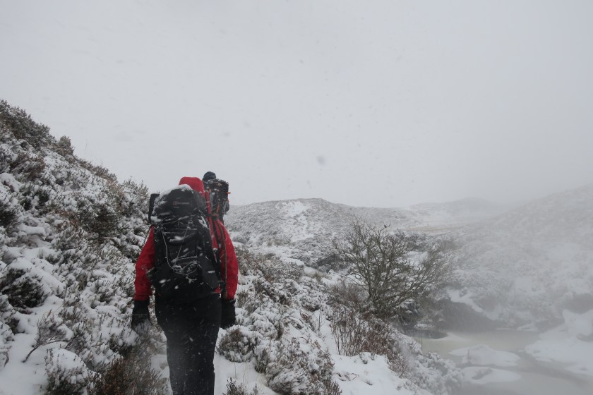
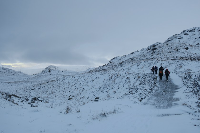
It’s a more leisurely start this morning and we’re walking by 10, but we don’t have a long route planned. Up Ben More, over the top, down to the bealach, into the valley and then follow the track back. It’s raining as we start and after ascending via a track, we turn up the muddy hillside where soon the ground and air are filled with snow. It’s here that Rob decides that a niggle he’s got is too sore to continue, so off he goes and takes his car with him but he offers to come and pick us up once we’re finished.
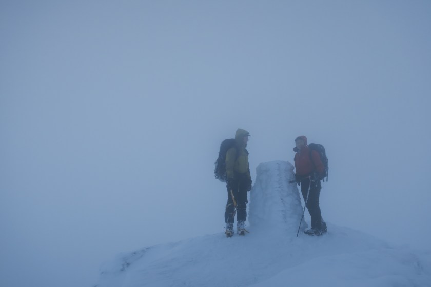
Visibility is poor but we’re sheltered from the worst of the wind and we gently zig-zag our way up. After a quick stop we spot the tracks of an individual who’s about an hour ahead of us so we use them as a guide through the uneven terrain. Soon we’re amongst icy rocks and I must admit that looking around and down, my knees wobbled slightly. If you were to slip it looked as though there wasn’t a lot to stop you. Logic told me I would stop because the ground and snow were mostly soft and not sheer but even so I felt exposed. It was time to don the crampons, after which I felt much more secure. We eventually reach the plateau when 4 figures appeared from our left – they’d come up the more exposed NE ridge and look chilled to the bone. We wished them a happy new year, stood by the trig point for the briefest of moments, took a bearing and headed off towards Bealach-eadardh-Bheinn.
We reach the bealach and turn down towards the valley. The lone walker ahead of us appears from behind; he’s been up and bagged Stob Binnein (we’ll have to come back another day!). We’re steadily descending but then find ourselves amongst about the only crags on this side of the hill. Florrie is in front, takes a sideways step and the snow gives way. She slides down the rock and comes to stop about 3-5m below in a mound of snow, she used her ice axe but I’m not sure it helped her much in this soft snow. I decide to turn and face the hill but there isn’t enough texture in the rock for the front spikes of my crampons to grip on to. I try to step down, but I know the inevitable is coming. I take one more small step and then slip, also sliding to a gentle stop. Ellen tries to pick an alternative route and gets a meter or two lower but also slides down. We stand up, brush ourselves off and I’m relieved that we’re all ok. Our falls were not significant enough to cause serious injury however even a minor injury to one of us in this spot could’ve changed the dynamic of the afternoon.
As we approach the road, dusk is falling and we begin to walk back to the hostel saving Rob the trip out. With less than 1km to go he pulls up and picks us up anyway, I’m secretly glad that there was a breakdown in communication as I wasn’t looking forward to walking the rest of the way on the busy road in the dark. That evening the feeling within in the hostel is more subdued, no-one is pouring over maps and guidebooks, wide-eyed at the opportunities that this landscape presents. Instead it’s about how early people are setting off for the long drive home.
Total: 4 days, 29.8 miles, 4,017m of ascent and 2 pubs.


 - it was very handy for the hotel bar and distillery!")


 me, Marcus, Louisa and Lisa")