I spent 4 nights in Edinburgh. I did a sightseeing bus tour, I walked around the castle, the Royal Yacht Britannia, caught up on my blog, generally soaked up the atmosphere and did a bit of shopping. It’s almost impossible to rest in a city. I also saw a podiatrist who diagnosed me with sesamoiditis. Possibly damage to or a stress fracture of one of my sesamoid bones (a tiny bone under the big toe joint). In an ideal world, after 6 weeks of complete rest it should be healed but she knew I’d like to carry on so attached some specific padding to my insoles and advised that I take anti-inflammatories. She also said that if it gets significantly worse that I should stop because continuing in agony could lead to longer term consequences. I’m hoping that the padding does the trick and I can carry on, as having to stop now would be devastating. I also treated myself to a sports massage and the guy did a fantastic job of ironing out my stiff, tired legs and knotty shoulders.
View from the castleEnjoying the yacht
Edinburgh has been interesting, but busy. So busy. It’s peak season, on the cusp of the fringe festival and tourists of all nationalities wander the streets. It’s been a bit of a shock to the system; the traffic, the choice (of one sort or another), the sirens and just the sheer scale. The biggest place I’ve been since I left was – I think – Barnstaple which is not exactly huge and was a long time ago. I’m looking forward to getting back out on the trail but a bit apprehensive about how my right foot will cope.
Day: 72 – Thursday 3rd August
Started at: Linlithgow Station
Finished at: Falkirk Wheel
Miles: 11
Miles from LE: 870
Duration: 6hrs (10:30-16:30)
Trig points visited: 0
Ales imbibed: 0
After some morning faff I eventually got on a train out of Edinburgh at 10am. No less than 2 minutes after stepping off the train it started raining – just a brief shower and then 10 minutes later it was stair-rods. Luckily there were some strategically placed trees and I kept out of the worst of it and then stayed dry for the rest of the day. I walked along the Union Canal all day, sometimes there was a rural view (a horse that had moments earlier given birth to a black foal) and other times very urban (a young offenders institute). The two highlights were the Falkirk Tunnel and the Falkirk Wheel.
The scary tunnel!
It’s 636m in length and was dug because the local landowner didn’t want the canal to spoil his view and so demanded the canal go through the hill. It was quite drippy and eerie in parts, but lit just enough.
The wheel, in contrast to a crude hole through a rock, is a feat of modern simplistic engineering. It replaced a set of 11 locks that had fallen into disuse and were dismantled 70years previously. There is something mesmerising about its elegance and many people stand rooted to the spot watching it rotate.
Falkirk Wheel
My foot has been ok, I don’t feel like the padding is a panacea but I find tow paths quite hard going anyway so it’s an unfair expectation. Not just because of the hard surface impacting my feet and knees but also the lack of variability of movement in the feet and leg muscles. Even without any issues I find it hard not to become conscious of my gait because of the monotony. I’m looking forward to getting off the tow path (2 more days!) and seeing how I fare on a more irregular path.
Day: 73 – Friday 4th August
Started at: Falkirk Wheel
Finished at: Twechar, nr Kilsyth
Miles: 11
Miles from LE: 881
Duration: 6hrs (11:00-17:00)
Trig points visited: 0
Ales imbibed: Seven Giraffes
I started slowly and the day continued in the same vein. I would walk for a while, stop, take my boots off, rest, then back on with the boots and away again. This being the first time on the trip that I’ve been properly suffering physically has knocked me for six a bit. I was expecting that if I made it this far that I’d be a walking machine and that it would only take something major like a fall or bad sprain that would stop me getting to the end. Instead I have niggles that dominate my thoughts and stop it from being fun – that and sodding tow paths.
Enough of my down beat drawl. Today had a distinct second chapter.
After a nice beer at a hotel by a marina I continued the 1.5miles to the campsite. When I arrived it was locked up and didn’t turn out to be a touring site – it was an adventure/activity centre which also offered camping. I gave the number a ring and left a voicemail but didn’t hold out much hope. So I started to consider the alternatives. No other campsites and according to research no B&Bs. There was a potential wild camping spot but I was out of water and there were no streams around, just a stagnant canal. I walked just 100m and there was a B&B sign hanging outside a farm, so I thought I’d give it a shot. A lovely Scots lady answered the door and unfortunately they had no vacancies. Could I camp? Without a moment of hesitation she said; “aye, roond tha back”. Within 2 minutes of pitching my tent on a lovely lawn I was presented with 2 fresh eggs from the hens that were now pecking at my bag. And just 10 minutes later I was offered a bowl of steaming hot soup and 2 slices of garlic bread. Oh how the tide can turn so quickly. William and Elizabeth’s generosity was so heart warming – as was the soup! I tried to offer them some money but they wouldn’t take it.
I woke up at 6:30, or more accurately; having not slept a wink because of the wind flapping the fly sheet I sat up at 6:30 and it hadn’t started raining. I had breakfast and started packing up but just as I was ready to emerge the rain started. So I hurriedly packed up the now damp tent. The rain then got heavier and more persistent. I followed Dere Street more or less all the way to Jedburgh and arrived at the campsite while it was still very much morning.
Dere Street
I had decided to have a day and a half off because Jedburgh has some history to learn about and I felt I needed to ease myself back in to carrying the full weight again. The campsite wardens let me pitch up and with the shower block about to close for cleaning I raced to get pitched, unpacked and into the shower. I think I set a new site record – 35mins from arrival to all sorted and showered! Having barely slept I decided to try and nap. Sleep appeared to allude me so I headed out in search of lunch. Mission completed, I spent the rest of the day and night in my sleeping bag feeling exceedingly snug as the rain fell on the tent – when I’m not walking I can be very lazy!
Day: 65 – Monday 24th July
Started at: Jedburgh
Finished at: Melrose
Miles: 15
Miles from LE: 791
Duration: 8.5hrs (9:30-18:00)
Trig points visited: 0
Ales imbibed: 1x Ossian
I spent Sunday learning about Mary Queen of Scots (who I never studied at school) and about jail conditions in an 1820s prison. Undoubtedly they were bad but not as bad as they could’ve been. Jedburgh Gaol is a fine example of a John Howard (prison reformer) prison; the debtors slept in cells but spent the daylight hours relaxing and conversing with other inmates in the day rooms. They had fireplaces and were able to receive food stuffs from visitors that they could cook for themselves. The Bridewell where the thieves and vagrants were locked up would have been much worse with hard labour being the daytime occupation. Everyday is a school day!
Jedburgh Gaol
Today the walking was either on the St Cuthbert’s Way which coincides with Dere Street, the Four Borders’ Abbeys Way (such a mouthful) or along the River Tweed. The vast majority of St Cuthbert Way walkers follow it from west to east (Melrose to Lindisfarne) along the route his life took which makes perfect sense. I was going east to west and so everyone I passed made quizzical sounds as if to say, aren’t you going the wrong way?
The first landmark was Monteviot House and Gardens which you see disappointingly little from the path, but I stopped at the cafe for tea and my first authentic shortbread. Next up was Lilliard’s stone. Another history lesson, although this is perhaps more myth than fact. There are many stories but the jist is that at the Battle of Ancum Moor a Scotswoman who’s lover was killed took to the battlefield and despite her legs being chopped off she continued to fight. Her tomb is on the ridge and the inscription reads:
‘Fair maiden Lilliard lies under this stane
Little was her stature, but muckle was her fame;
Upon the English loons she laid mony thumps
And when her legs were cuttit off, she fought upon her stumps.’
Lilliard’s Stone
Shortly after this Dere Street becomes the current line of the A68 so the route dives off to the Tweed which made for some very pleasant walking. Passed by Dryburgh Abbey – one of the 4. St Boswell’s and Newtown St Boswell’s didn’t grab me so I cracked on to Melrose. My feet were starting to ache in new ways which was unexpected so I skipped out the Eildon Hills – disappointing because they are such distinctive hills but I vowed to come and walk them another time. The final landmark on the way into Melrose was a stone under a tree which supposedly marked the spot where Thomas the Rhymer was met by the Queen of Elfland and taken to a fairyland for 7 years where she gave him the gift of prophecy.
Point of entry to Elfland
The glimpse of Melrose I got was enough to make me decide to come back and explore it properly, I could do that and walk the Eildon hills at the same time.
Day: 66 – Tuesday 25th July
Started at: Melrose
Finished at: Brown Knowe
Miles: 13
Miles from LE: 804
Duration: 8.5hrs (9:30-18:00)
Trig points visited: Three Brethren, 464m – NT432319
Ales imbibed: 0
Another day another long distance path. This time the Southern Upland Way. Initially it followed the Tweed and a not so disused railway (since the guidebook was published they’ve reopened a station at Tweedbank and a stretch of line) which still had a footpath. South of Galashiels I opted to take a diversion around the south of Gala Hill which was a pleasant – but muddy – woodland path, then it was through farmland to Yair. On the sides of the path up through Yair Hill forest were so many mushrooms; a mycologists dream!
Mushroom montage
It was a steep climb up to the Three Brethrens – a hilltop with 3 chunky cairns marking the point where three estates meet and also the highest point of the Selkirk Common Riding ride.
Three Brethrens
I’d not seen any other walkers on the Southern Upland Way all day, and at 4pm just when I thought I could sit peacefully and reflect at the summit, no less than 9 people passed by. Nine people…for me that’s like standing in the middle of Piccadilly Circus!
I continued on for a few miles heading for the top of Brown Knowe where I’d be looking for a wild camping spot. I was very glad to have found one – the sun and clouds were my entertainment for the evening. The rapid movement of clouds – a warning sign of a breezy night – made for an ever changing scene, with the sun setting in the background. The camera doesn’t do this justice but you get the idea, the layers of hills went as far as the eye can see.
Sunset on Brown Knowe
I had what I think was a Rough Legged Buzzard for company too – which was a privilege.
Day: 67 – Wednesday 26th July
Started at: Brown Knowe
Finished at: Innerleithen
Miles: 6
Miles from LE: 810
Duration: 2.5hrs (8:30-11:00)
Trig points visited: 0
Ales imbibed: 1x Isle of Arran Blonde
I awoke early but had slept like a log! It was 6:30 and as the rain hadn’t started I rolled over for a bit of a doze and was woken up at 7 by the rain on the tent…schoolgirl error. When I opened the tent I could see very little compared to the night before, just my immediate surroundings appeared through the fog.
Foggy forest
I pressed on through the Elibank and Traquair Forest across Minch Moor on the Minchmoor Road – used for 800 years as the main route through southern Scotland. There were some intriguing art installations along the way, one of which was this:
‘Moor Circles’
The accompanying plaque gave some pretentious artistic waffle but in essence it might look like a series of circles mown into the moor, but they are in fact large ovals that when viewed from the path appear to be perfect circles.
As I descended the rain really set in and my ambitions to walk to Peebles slowly ebbed away. Instead I would head to Innerliethan. When I arrived I saw that the campsite was in possession of some ‘glamping pods’ and they had one available, so I took it. It had a little electric heater which I switched on almost immediately and having just spread out all my wet kit, the steam set off the deafening smoke alarm. I was embarrassed by the loud peel and rushed to open the doors. I put on my apologetic face ready to explain to anyone who sought out the source of the noise that penetrated their peaceful retreat. But no-one came. I was relieved not to have to apologise but then I realised, that at the sound of a smoke alarm no-one came to my rescue. I could have been burning alive in there and no-one batted an eyelid. Luckily for me it was just the steam and after tireless wafting the alarm eventually stopped. Note to self if you or the cabin spontaneously combust in the night, dial 999 – no-one else is going to bother.
Even the local hardy horses were sheltering from the rain!
Day: 68 – Thursday 27th July
Started at: Innerleithen
Finished at: Peebles
Miles: 10
Miles from LE: 820
Duration: 5.5hrs (10:30-16:00)
Trig points visited: 0
Ales imbibed: 1x Gunner
Having split 1 day into 2 I now only had 10miles to get to Peebles so I had a very relaxed morning. I even found the time to lay out my kit in a colour sequence which scratched some sort of organisational itch.
Rainbow of kit
The route first went through the grounds of Traquair House which claims to be the longest continually inhabited house in Scotland, I didn’t hang about as I’d come from the back entrance and was probably supposed to pay. After a brief stint on the road it was back to forest tracks and up to the remains of a Roman fort called Castle Knowe. I couldn’t find the path that was indicated on the map so did a bit of off-roading to get to the summit and enjoyed the serenity at the top. Upon leaving I begun a lap of the fort when I came across a path – d’oh! I descended for lunch where there were a few day walkers and dog walkers but no backpackers to be seen.
I managed to sneak into Kailzie Gardens via an unlocked gate – I was definitely supposed to have paid for this one, so I confidently strode through expecting a hand on my shoulder at any moment, but escaped. It was then road all the way to Peebles where I posted some maps, bought some new insoles and went to the pub (hotel). My feet have been troublesome – particularly my right foot which has been hurting on the inside (base of my big toe) and so I’ve been walking strangely to compensate therefore leading to some pain on the outside of my foot. It’s not only annoying, it’s harder to enjoy the experience when my thoughts are consumed by my feet and my gait. “Just walk normally, you’ve been doing it for 28ish years, just stop thinking about it and walk naturally…!”
Peebles
Day: 69 – Friday 28th July
Started at: Peebles
Finished at: West Linton
Miles: 12
Miles from LE: 832
Duration: 7hrs (10:00-17:00)
Trig points visited: 0
Ales imbibed: 1x Hurricane Jack
I had another slow morning, I think I’ve been using delay tactics because of my feet. If I put off getting going then I put off finding out how my feet are doing. I put the new insoles in and by the afternoon I had brief moments where my feet did not occupy my full attention – hopefully those moments will get longer until it’s business as usual.
It rained on and off in the morning and when the shower got briefly heavy I dived for the nearest shelter which happened to be a gorse bush. It was a tad prickly but it did the job! As I continued up the hill looking at my map to calculate the ascent I had just embarked upon I was passed by a nice enough looking middle aged chap in his car who shouted from the open window; “if you’re using a map, then you must be lost.”. What a prattish and nonsensical thing to say! This gave me enough material for a good 10 minute rant in my head. Idiot.
What a view!
The route went off-piste for the first time and it was easy enough walking on short heather and bilberry but then I went even more off-piste, deciding to skip out the summit of White Meldon and ended up in tall bracken which slowed me down slightly – it sort of tangles around your legs, but wasn’t particularly bothersome. The Meldon Hills are dramatic but not particularly wild – in fact their proximity to habitation attracts a number of ‘wild campers’ and therefore vandalism of facilities and unsightly litter. The ‘wild campers’ I saw were families who’d pitched up on a patch of flat grass by the side of the road with their full size caravans (or tent equivalents) and BBQs – the end of the valley is basically like being on a campsite except it’s free.
Wild campers
On the way to Rommanobridge I passed through the forest of the Cloich Hills and the mews of buzzards rang out. Their presence has replaced that of the curlews, lapwings and oystercatchers of the mid-Pennines. Despite their increasing frequency in recent days, whenever I hear one, I still stop in my tracks to watch them, enthralled by the grace with which they rise effortlessly on the thermals until they are a mere speck. On another wildlife note, the flora and fauna has also changed; the hedgerows and riverbanks have taken on a definite purple hue. There is the Scottish emblem; the thistle, the non-native invader; Indian Balsam and the native but aggressive Rosebay Willowherb.
Thistle
West Linton, my destination for the day is a gem. A village with ancient origins and a distinctly – dare I say it – English feel. With a very narrow high street and no less than 2 village greens. The restaurant was superb and unfortunately for future LEJOGers the only B&B won’t be around for much longer.
Day: 70 – Saturday 29th July
Started at: West Linton
Finished at: East Calder
Miles: 13.5
Miles from LE: 845.5
Duration: 8hrs (9:15-17:15)
Trig points visited: Corston Hill, 348m – NT094634
Ales imbibed: 0
Today was dominated by passing through the Pentland Hills – not an area I’d ever considered before. They might be flanked by built up areas but when you’re stood in the middle they feel very wild and rugged. I think it’s definitely a taste of things to come, if I am to go up the west coast. In the middle you pass through Cauldstane Slap – wonderful name – a distinctive col which also forms the boundary of the Borders and West Lothian.
Cauldstane Slap
I also had a close up encounter with some proper hairy and horned Highland coos. I’m not sure why but I feel less cautious of Highland cows, part of it might be the memories of driving down a narrow lane to infants and primary school for 6 years where there was often a herd of hairy cows. Occasionally my mum would stop the car and we’d get out for a closer look. I particularly remember the randomness of their presence – sometimes they were there and other times not, the anticipation of starting off down the lane not knowing if they’d be there and finally the squeals of excitement and shouts of ‘hairy cow’!
Highland Coo
Just before East Calder the route rose up to Corston Hill which provided great views to the north and east; to the Firth of Forth and its bridges, Edinburgh and Arthur’s seat dominating the skyline.
View over West Lothian
Unfortunately my feet, or more accurately my right foot, has not improved and so I’ve decided that I’m going to divert by train to Edinburgh to take a few days rest, seek some advice and possibly purchase some new boots. Other than wandering around for a few hours waiting for a train, I’ve not been to the Scottish capital before so it’s a good opportunity to see the sights.
Day: 71 – Sunday 30th July
Started at: East Calder
Finished at: Linlithgow Station
Miles: 13.5
Miles from LE: 859
Duration: 6.75hrs (9:15-16:00)
Trig points visited: 0
Ales imbibed: 1x Edinburgh Gold
Having taken the decision to stop off in Edinburgh, today had a different feel about it. I was on the Union Canal towpath all day and was just knocking off the miles to Linlithgow from where I knew my trip would be taking a hiatus. Towpaths have their pros; no navigation, flat, and usually something of interest to look at. However they are usually hard surfaces, monotonous and mind numbing.
Lin’s Mill Aquaduct
My foot had continued to give me grief that would occasionally stop me in my tracks, so I arrived at Linlithgow station and jumped on board a train with mixed emotions; looking forward to exploring Edinburgh but some decisions to be made and possibly money to be spent on diagnosis and/or treatment of my ailment.
On Monday we had a day off and visited Kielder Forest and Water. Some facts I learnt:
25% of all felled timber in England comes from Kielder
3.5million trees are planted in Kielder every year
The reservoir is the biggest man-made lake in Northern Europe
It holds 200,000 million litres of water – enough for a shower for every person in the world. (I confirmed this claim and calculated that with this much water, a shower head that uses 7.75L per minute and a current population of 7,520,378,800 we could all have a 3min 26sec shower.)
They have the most bonkers mini-golf course ever! It has no predetermined course just a set of starting points and holes – each group decides its own combinations. Amidst the chaos, I somehow managed to beat my golf-mad dad!
Back to Haltwhistle station and then I walked through the streets of the town which claims to be at the centre of Britain; if the centre is the midpoint of the longest north–south meridian and includes the Orkneys, but not Shetland Isles. Other methods are available: https://en.m.wikipedia.org/wiki/Centre_points_of_the_United_Kingdom.
Centre of Britain Launderette – really?!
Out of the town the path rose through fields and across a road to reach Hadrian’s Wall. We had devised a complex schedule which allowed each of my parents to walk a section of the wall without doubling back to get the car or tend to their very old dog who practically lives in the boot – out of choice – whilst on holiday. So firstly I picked up my mum and we walked up and down and up until we reached Green Slack where the views were extensive.
Me and mum on Green Slack
We dropped back down to a car park to do a relay-esque swap with my dad. We then went up and by Peel Crags and saw Sycamore Gap. At the next junction I turned north to continue along the Pennine Way and my dad dropped off to the south to meet my mum at the pick up point.
Me at Sycamore Gap
The rest of the day was moor and then my first experience of large sections of forest where it was surprisingly boggy underfoot. I thought that the vast swathes of trees would soak up every molecule of water, but alas it appears there is just too much water in these parts and so I got very wet feet having opted for trainers – mainly just because I could!
As I was reaching the point where I had agreed to meet my dad I looked at my watch and saw that I was 5mins early, that’s pretty good timing I thought and it’s no time at all to wait. I continued down the path approaching the lane when the car appeared and just as I climbed over the stile my dad arrived alongside it, so I opened the door and leapt in – A-Team style! We were gobsmacked by the perfection. It was extraordinary that we arrived at the exact same spot at the exact same time.
Tonight was my parents’ last night and mine with the extra home comforts – we played cards and had some brandy.
Day: 61 – Wednesday 18th July
Started at: Willowbog, nr Stonehaugh
Finished at: Bellingham
Miles: 7
Miles from LE: 740.5
Duration: 3.5hrs (10:15-13:45)
Trig points visited: 0
Ales imbibed: 0
I’d arranged to stay an extra night at the campsite sans caravan so all I had to do after being dropped off was walk the 7miles back to the campsite. It was a slightly teary goodbye and I waved my parents off down the lane. Farewell comfy pillow, goodbye clean non-hiking clothes, cheerio well rounded meals and packed lunches, au revoir Dusty (the dog) oh yeah and ciao mum and dad!
It was a fairly uninteresting 7miles but I did find a ‘Pit Stop’ for Pennine Way walkers. Little signs and arrows pointed you in the direction of a former stable building that had been transformed into a hikers haven/treasure trove. It had seats, snacks, drinks in the fridge, a kettle plus accoutrements, toilet and shower, washing machine and tumble dryer (these may have just been the owners’), oh and a little box of hiker goodies – a spare guidebook, plasters etc. As it happened I didn’t really need anything, but I could have done with something similar many a time. Such generosity from the owner to let hikers hang out in their barn – love it. It got me thinking; why haven’t I seen more hospitality based on honesty? Perhaps it’s just too much effort.
Pit Stop
The other small piece of drama was coming across an injured sheep. It had a wound on its back leg that had attracted flies and it wouldn’t walk – it just stood there no matter how close I got, I could even stroke it. I took a note of the number on its ear tag and reported it to the next house I came to. Hopefully the girl I spoke to managed to find the farmer and it’s been looked after.
Got back to the campsite in time for lunch and spent the rest of the day chilling out in the campers lounge and getting myself ready to head off again.
No more support crew!
Day: 62 – Thursday 19th July
Started at: Bellingham
Finished at: Forest View Walkers Inn, Byrness
Miles: 16
Miles from LE: 756.5
Duration: 8hrs (9:00-17:00)
Trig points visited: 0
Ales imbibed: 1.5x Thirsty Walker – Forest View Walkers Inn Ale
After setting off from Bellingham, heading through a farmyard, getting chased down by a dog and hitting the moors again, I found a number of other Pennine walkers. There was a South African lady who’d walked from Chepstow for charity and was joined by a friend, Greg an Australian chap who likes coming to the UK to do the long distance trails and a group of 3 more Australians (father and 2 sons).
Nothing much else happened so here is a picture of a sheep with massive horns. I’ve seen A LOT of sheep since Land’s End – tens of thousands – and this one has the biggest horns by far.
A fine specimen – although not sure how much it could see
At around lunch time I met Claire another Pennine wayfarer. Then it was a long trudge down a forest road which I hated. There were a few lorries that barrelled along them too – without slowing – which was lovely of them. I kept myself going until I reached the edge of the forest where there were picnic benches. I was going to treat myself to a long sit down, boots off ‘n’ all. But as soon as I sat down the midges attacked. They put a very quick end to my plans and so I picked up my heavy bag and carried on grumpily. I could definitely feel the full weight being back on my back.
Forest track with lorries
My destination was the Forest View Walkers Inn and I’d arranged to camp in the back garden for free provided I bought a 2 course dinner and had breakfast. At £22 it was a good deal as there weren’t any shops or restaurants in Byrness. It was here that I’d meet everyone that I’d seen on the trail today plus a few others who were staying a second night. (The last day of the Pennine Way is 28miles which is too far for most people so Joyce and Colin have a minibus to pick walkers up halfway to Kirk Yetholm at the end of day 1 and then drop them back the next morning.) One of those with just 1 day left was Dom who I’d met on day 50 (over 2 weeks ago) – how we’d not crossed paths in the interim I have no idea. (Hi Dom if you’re reading! Hope you enjoyed you’re free half pint in KY!) The inn was fantastically sociable with everyone sharing experiences and comparing notes, plus spirits were high as everyone had only 1 or 2 days left. The hand pumps in the corner of the living room helped! As did Colin’s many tales of walkers he’d seen pass through his doors.
Just another note on the Walkers Inn – not only were Joyce and Colin lovely and interesting hosts, the food was great, the beer was good, and everything was clean and tidy. But here’s the clincher – the drying room! Not only did it work but when each walker arrived Colin would take your boots from you, take out the insoles and number with chalk both the boots and the insoles. He’d then prioritise the wettest boots and rotate them around the rack accordingly. In the morning, once they were all dry, they were paired up and brought into the conservatory for everyone to slip on…now that’s service!
Day: 63 – Friday 20th July
Started at: Forest View Walkers Inn, Byrness
Finished at: Dere Street nr Shibden Hill
Miles: 13
Miles from LE: 769.5
Duration: 7.75hrs (9:15-17:00)
Trig points visited: 0
Ales imbibed: 0
Last day on the Pennine Way – I had to make a note on my map of where to turn off so I didn’t end up going towards Kirk Yetholm. I set off with Greg straight up Byrness Hill which is a steep and slippery muddy bank.
View from Byrness Hill
Once atop the moors we met a few more walkers and we eventually caught up with Claire. We passed by Chew Green – a significant Roman Fort complex – and not long after I turned left off the Pennine Way and across the border into Scotland!
I’ve walked to Scotland – yay!
I waved goodbye to my companions and on my own again I got a little bit emotional; “little ol’ me has walked 750+miles across the length of her own country”.
I had lunch at the top of Blackhall Hill staring into the land of haggis, whiskey, tartan and Mel Gibson in a kilt. As I descended I looked around and the landscape definitely seemed different. There were lots of interesting lumps, bumps and humps and I was philosophising over whether I thought it was different because I knew it was a different country or whether if I’d been ignorant to the border would I notice a change? Either way I could definitely sense a change, even if it was just mentally and emotionally.
The change in scenery – I love the textures
I was now walking along Dere Street which is a Roman road built well before Hadrian built his wall. It runs from York to Edinburgh and I’d be walking it for the rest of the day until I found a wild camping spot. The border did signify a game changer – I could now legally wild camp almost anywhere, which makes the planning a bit easier. No campsites? No worries, just stock up on food, refill water from a stream and I’m good to go wild camping anywhere. I had my eye on a particular hill and getting closer I started looking for spots. When Dere Street met a lane there was a bench on a flat-ish area of grass. Looking ahead, the hill I’d seen on the map was nothing like reality. The area of woodland had been felled, the walls/fences had been removed and it was littered with cows and sheep. The area by the bench would be more than sufficient so I stopped there and then. It was only 5pm so I didn’t pitch up, instead I wrote my diary, did some stretching and sat upon my bench. The lane was very quiet, only 1 or 2 cars an hour or so, that was until no less than five 4x4s came screeching to a halt right alongside me and turned my tranquil spot into a car park. Well I was fuming, “who the bloody hell are this lot and what do they think they’re doing just parking all over my abode?” Then Tony Robinson got out, and all was forgiven! He was with a TV crew and they’d arrived to do some filming on Dere Street for a series called Ancient Tracks. Once he’d heard about what I was doing there, he came over, shook my hand, congratulated me and posed for a photo. I spent a good hour or so talking to various members of the crew (who gave me 2 bottles of water and a banana) and before I knew it they were gone again. What a surreal moment!
Me and Sir Tony
It was only later on that I found out he’s Sir Anthony and I’d never met a knight before. It was probably a good thing I didn’t know beforehand because I wasn’t able to string a sentence together anyway, let alone come up with some quip about a cunning plan. So had I known I might’ve panic curtsied or something!
Once they’d gone I cooked my dinner, sat on my bench to watch the sunset and reflected upon an event filled day.
There was an air of excitement as I packed up and left the 100s of midges behind. My parents had travelled up with the caravan from East Sussex to be my support crew for 10 days and we arranged to meet at the Tan Hill Inn. Which meant, well, bliss. A super light day bag, no worries about accommodation, no thoughts about where my next meal would come from or how I might imaginatively cook it on my stove, and I’d put in a request for some extra clothes, a proper pillow and a nice fluffy towel – a respite from microfibre!
I opted to take a path that was not the Pennine Way – gasp – but seeing the Way unnecessarily climb and fall on the opposite side of the river I felt vindicated as I only had a gentle rise onto the moors. Once up there it rained on and off so I sheltered in a cow-‘ause for my lunch. With less than 5miles to go, I had to consciously slow myself down as I knew the earliest my parents would be able to get there was 4pm and I’d call them when I arrived to let them know I’d made it.
My excitement at reaching Tan Hill Inn
The inn – which at 530m is the highest in England and possibly one of the remotest – is a popular spot for walkers, cyclist and bikers as it offers camping, bunkhouse and B&B accommodation. Plus it remains open in the foulest weather even when they’ve been snowed in for weeks they still welcome visitors. As I reached for the door handle I spotted a handwritten sign stuck to the window which read; “Due to an issue with the water supply we have had to close, sorry for any inconvenience”. Well, I nearly cried, but the porch was open so I resigned myself to waiting there. Then a guy came over, unlocked the door and said; “we’ve taken pity on you, come on in and sit by the fire and dry yourself off!”. I was so grateful for the warmth but pushed my luck by asking if the hand pumps still worked and they did! I supped my beer and steamed by the fire as the staff ate their lunch and I gleaned more information about the issue. Then the landlady appeared and asked the staff to begin a deep clean – they may as well make the best of a bad situation. Meanwhile the phone was constantly going; the message had gone out and those with bookings were calling to find out more or just complain. Amidst the melee someone left the door unlocked and so customers kept letting themselves in – despite the sign; a group of 4, a couple, another 3, another couple. The landlady was sat by the door and welcomed each patron with a smile and the same line; “we are officially closed as we don’t have any water, so you can’t use the toilets and you can’t have tea or coffee. But if you’d like an effing drink, you can pour it your-effing-self or eff off!!”. So that is just what they did, they went behind the bar, found a glass and pulled their own pints. It was absolute joyous chaos and provided great entertainment whilst I waited for my parents to arrive.
When they did, there were hugs and a few tears. I pulled us some drinks and we caught up. Then it was back to the campsite where I’d be pitched for 5 whole nights.
Day: 55 – Tuesday 11th July
Started at: Tan Hill Inn
Finished at: Wythes Hill, B6276
Miles: 14
Miles from LE: 665.5
Duration: 6.75hrs (10:45-17:30)
Trig points visited: 0
Ales imbibed: 0 (but a G&T and a glass of wine instead!)
After a very relaxing evening in the caravan, one of mum’s home-cooked lasagnas, a G&T and a glass of wine it was back to Tan Hill in the morning for the walk across Sleightholme Moor. With only a day pack I felt like I was flying, it was great!
It’s so light!
Somehow Allan – with a hand he pack – caught up with me, he was walking the Pennine Way as part of his PTSD therapy and raising money for a veteran’s charity having served in the army for 17yrs +. We walked and chatted, crossed under the busy A66 and continued across the moors. At a cairn I stopped for lunch and Allan decided that was him done for the day so he pitched his tent. Another couple of walkers caught up – John and John who I’d met in the Tan Hill the day before.
Shortly before the arranged pick up point there were a couple of nature reserves. One was ‘Hannah’s Meadows’ named after Hannah Hauxwell who farmed there using such simple methods that rare flower species thrive and it is now designated an SSSI. I recommend the original documentary from the 1970s called ‘Too Long a Winter’ and its sequel ‘A Winter Too Many’ about her frugal life on the farm (both are on YouTube). I had a peaceful moment in a hide looking over the reservoir; 2 oystercatchers, a heron, a gull and lots of sheep.
View from the hide
In the evening dad cooked a BBQ and one of my best friends; Emma happened to be in Penrith for work and she was able to drive over for some of my dad’s charred sausages. It was a great surprise and a bit of a shock to the system to suddenly be surrounded by friends and family – I’m not used to so much conversation and having to verbalise my thoughts.
Me and Emma
Day: 56 – Wednesday 12th July
Started at: Wythes Hill, B6276
Finished at: Langdon Beck YHA
Miles: 11
Miles from LE: 676.5
Duration: 6.5hrs (10:00-16:30)
Trig points visited: 0
Ales imbibed: 1x Rivet Catcher
Today my dad was going to join me for a large part of the day but first I had to get up over a hill and down in to Middleton-in-Teesdale. The 2.5 miles took over the estimated hour because I had binoculars and so was distracted by the many birds plus I dropped my map and had to go back about 1/4mile to find it. I found my parents at the coffee shop and then me and dad waved goodbye to mum and set off along the Tees. It was a lovely walk along the dale through meadows and copses, plus it was perfect walking weather. We passed by Low Force and High Force where there were many more walkers but out the other side of the attractions we were back to having the trail and the juniper trees (with gin berries) to ourselves.
Low ForceHigh Force
It was a short climb at the end of the day up to Langdon Beck YHA and dad was pleased to see mum and the car. He had now completed 0.7% of LEJOG but didn’t think he could tackle the remaining 99.3!
Me and Dad
Day: 57 – Friday 14th July
Started at: Langdon Beck YHA
Finished at: Dufton
Miles: 12.5
Miles from LE: 689
Duration: 5.75hrs (9:45-15:30)
Trig points visited: 0
Ales imbibed: 1x Ruskin’s
Yesterday we had a day off and went to Richmond for some gear shopping and lunch.
Then in the morning it was back to Langdon Beck for the walk over the Tees, along a beck to Cauldron Snout Waterfall (which you need to scramble up the side of so I was very glad for the small, light bag), then on to High Cup Nick and down to Dufton.
Cauldron Snout
I’d never heard of High Cup Nick before but I think it will stick in my memory forever. Coming from the south, you come from a narrow-ish river valley. As it opens up you walk across the plain and then wham! you’re stood at the top of a band of rock that surrounds this huge bowl-like feature with views to the Lake District. Absolutely stunning.
High Cup Nick
Day: 58 – Saturday 15th July
Started at: Dufton
Finished at: Garrigill
Miles: 15.5
Miles from LE: 704.5
Duration: 7.5hrs (9:30-17:00)
Trig points visited: Cross Fell, 893m – NY687343
Ales imbibed: 0.5x Angel Ale
Today I was going to reach 893m – higher than I’d been so far and higher than I would get for the rest of the trip – even in Scotland. I did a sun dance but unfortunately I must have been communicating with the low mist and cloud god. After an hour of ascending towards Green Fell I went into the cloud and could only see about 20-30m around me. It stayed this way until an hour before reaching Garrigill when I descended out of the cloud. This weather made for some great photos…!
Little Dun Fell
Great Dun Fell – there is a giant radome in that cloud somewhere
Cross Fell
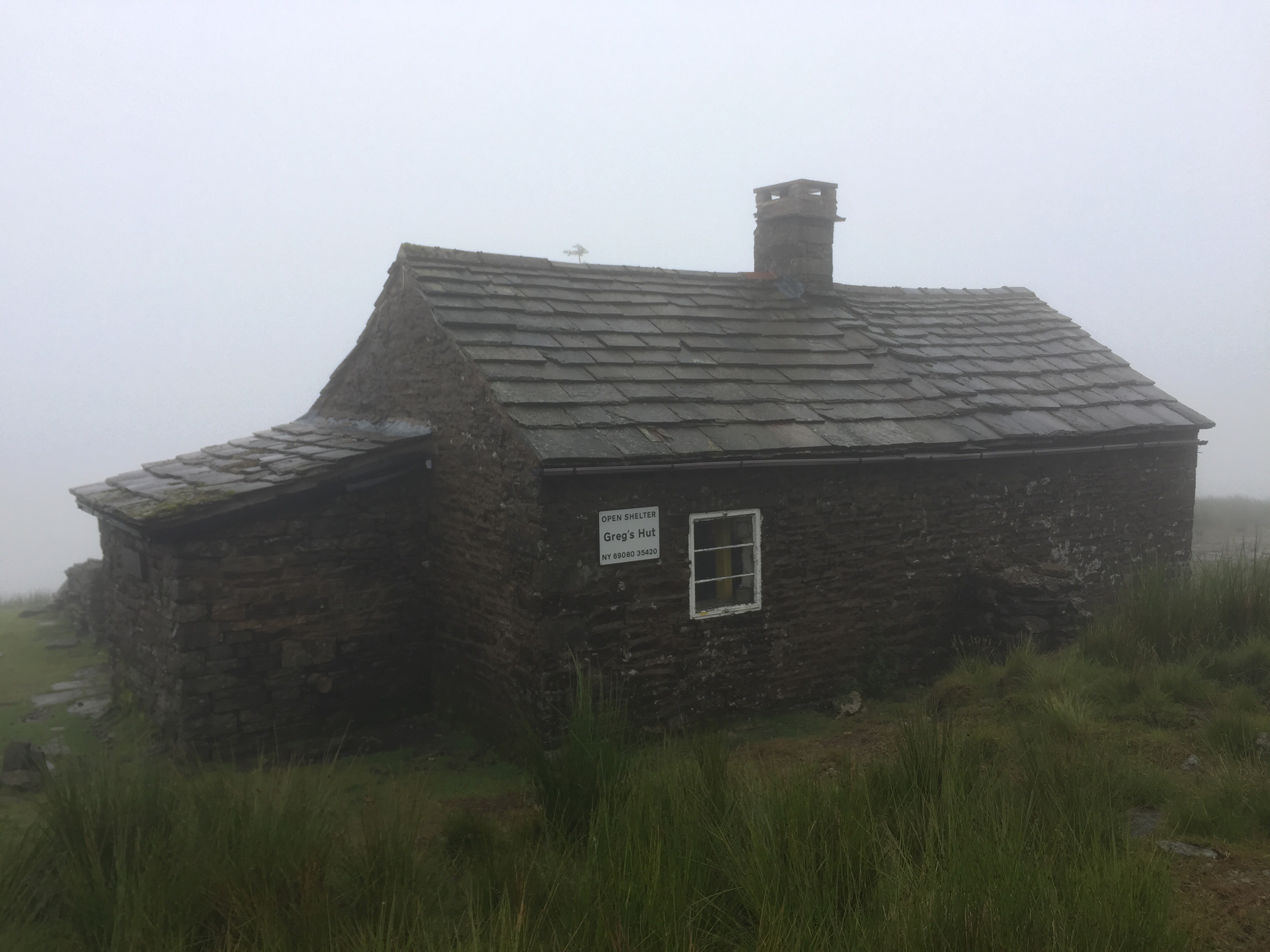
I appreciated the use of Greg’s Hut as a respite from the wind and rain whilst I had my lunch. I expected to find other wayfarers settled in for the night having decided not to continue battling through the weather, but I had it to myself. The final 6.5miles down the old corpse road were grim and hard on the feet – again I was glad I didn’t have the full pack.
Greg’s Hut
Whilst I was out on the hills my parents moved base camp from Barnard Castle up to Bellingham.
Day: 59 – Sunday 16th July
Started at: Garrigill
Finished at: Haltwhistle Station
Miles: 17
Miles from LE: 721.5
Duration: 8hrs (9:00-17:00)
Trig points visited: 0
Ales imbibed: 1x Wey Aye Pale Ale (this is not me being derogatory about being in the North West, this was the name of the ale)
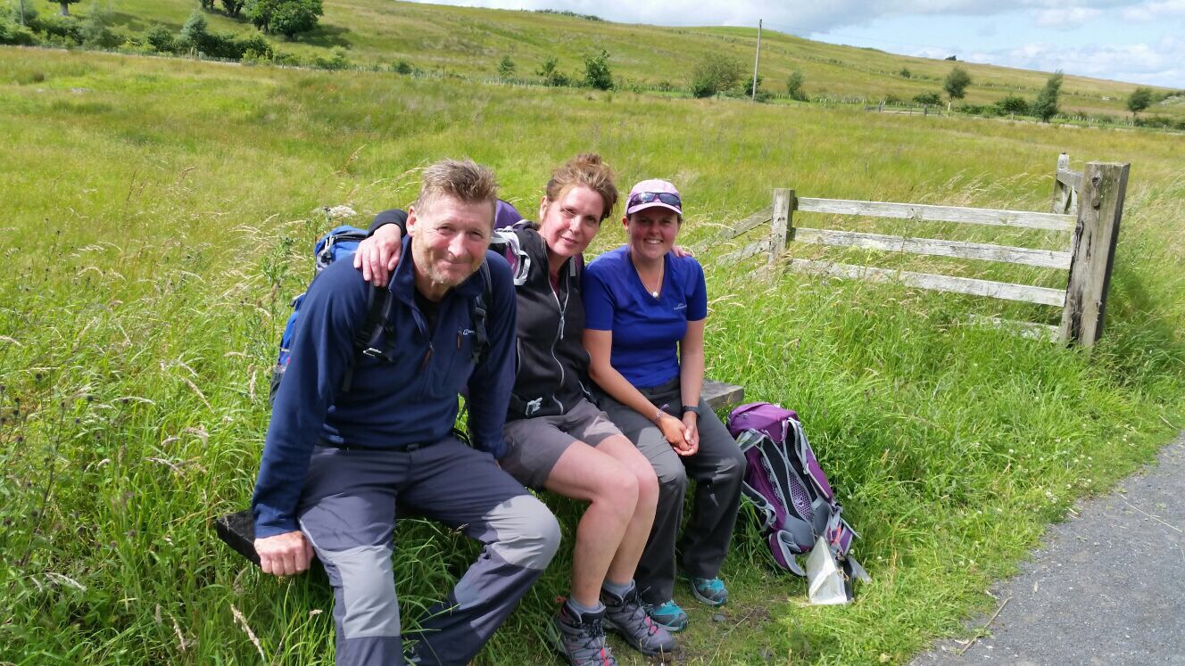
It was a special day today because I had arranged to meet Ronnie and Julie (see days 8 and 38) who were going to join me for half a day of walking. We met in Garrigill and the weather was much improved – perhaps my sun dance had got stuck in an outbox.
We walked the Pennine Way up to Alston where they bought me coffee and cake and then we continued along the railway line, which was not all disused – it had steam trains running along part of it – and it was unlike many other railways lines. It was not completely straight, flat, tarmacked and enclosed, instead it was refreshingly open with nice views. We talked for hours, sharing tales of the places we had stayed. Our differing experiences of the same places were usually dependent on the weather at the time. At 3pm Ronnie and Julie turned around to walk the 12miles back to Garrigill – a 24mile day(!) – and I continued to Haltwhistle (a mere 5 extra miles) . Their parting gift was a small plastic pop bottle filled with whiskey, a very thoughtful present.
Rikki the Rockhopper and Fury the mini Schnauzer puppy picked me up on Friday as planned and drove us to the campsite. It felt like a fast way to travel, the hedges zoomed by the window and the view changed remarkably quickly.
Fury…awwwww!
On the Saturday morning all the other small tents had popped up overnight and once we’d agreed a route we set off. Having only a day bag I felt like I could gallop along. Ahh such relief. From West Burton we reached the top of the ridge at Height of Hazeley with ease and added some mileage by wandering around looking for a dropped camera, which we never found. Then it was on to Brown Haw and eventually Buckden Pike along the ridge line which was a pathless, tussocky, bog slog.
I have friends!
From Buckden Pike we picked up a footpath and eventually a track which led us down to farmland. About 100 stiles later we were back at West Burton and it would’ve been rude not to walk past the pub and not stop.
So I’d done a tough 17.5 mile walk and got no closer to John O’Groats…! Hmm.
Day: 53 – Sunday 9th July
Started at: Hawes
Finished at: Usha Gap, Muker
Miles: 10
Miles from LE: 644.5
Duration: 6.75hrs (10.30-17:15)
Trig points visited: Great Shunner Fell, 716m – SD848973
Ales imbibed: 0
Today I was back to heading in a line due north. Chris the Rockhopper had also been suitably knackered by the previous day’s walk and so offered to take me back to Hawes and then walk with me for the first mile and a half to Hardraw Force – at 98ft it’s the highest single drop waterfall in England. Entrance is through a pub which is novel and it was quite impressive but I’m not sure about £2.50 impressive.
Me and Chris at Hardraw Force
After this I was back on my own again for the trudge up Great Shunner Fell – the guidebook had warned me about the false summits but at the 10th I was getting a bit bored of thinking I was nearly at the top so just forgot about it and marched on. By the time I got to the top the cloud and mist had rolled in and I couldn’t see very far but it was a uncharacteristically dry mist. I’ll take that!
Atop Great Shunner Fell with “extensive views”
On the way down, the sun came out and by the time I got to the pretty little village of Thwaite I was roasting so it was a good job the tea room was open. There was less than a kilometre left so I hauled on my pack, ambled down to the campsite and pitched up in a lovely riverside spot.
I left promptly as I knew I had a long day ahead of me and was looking forward to getting to the picturesque village of Malham and a night in the youth hostel. Soon after rising out of Cowling the drizzle began but I reached Lothersdale in good time. Unfortunately I was too early for the nice looking pub – it was only 10am! So I continued on climbing upwards; deeper into the cloud. Reached Pinhaw Beacon and enjoyed the spectacular view – not!
Me looking cheery at Pinhaw Beacon
By the time I got to Thornton-in-Craven I was pretty damp and my boots hard started to squelch. This village is crying out for a pub but unfortunately lacks one so a bench would have to suffice (during a brief pause in the rain) where I changed my socks. Just before reaching East Marton – and it’s pub! – there was a short stretch alongside the Liverpool to Leeds canal which included the double arch bridge. An odd feature that can’t be explained.
The double arch bridge
Unfortunately the pub lacked a fire or warm radiator – it was actually almost chilly inside – but what it lacked in warmth it made up for with a delicious steak sandwich. Once I was mostly dry apart from my socks and boots I stepped back out into the rain and promptly slipped down the stone steps back onto the towpath. Luckily no damage done. On arriving in Gargrave and being presented with a tearoom I flexed my will power and managed to walk straight on by – there were still a lot of miles to go today.
Having noted that the route crossed numerous fields (with saturated grass) I opted to continue along a track and cut back across just one field. Part way along my phone pinged and it was a photo from my dad of my mum enjoying the glorious warm sunshine back home in the garden. This tipped me over the edge and I burst into tears – “It’s not fair! Why can’t the sun come out here? What am I doing? This is miserable. I too could be sat at home enjoying the sunshine, instead I’m trudging through the rain. Was this whole LEJOG thing such a good idea?”. I rejoined the route and was quickly met by another walker and just about kept myself together as we introduced ourselves. This was Connor, on day 5 of walking the Pennine Way, a student who’d just competed his first year studying physics at Cambridge and as I would find out over the next couple of days was into ultra-light backpacking, that, and his brain is the size of a planet! He could tell me the weight in grams of virtually every item in his bag. (Hi Connor if you’re reading this – hope you’re progressing along the Pennine Way as planned with your very light bag!)
Conversation ensued for the remaining 6miles which made the time pass by much quicker and almost made me forget just how wet my feet were – sort of, although I think the squelching was audible. Walking over the crest of a hill and seeing Malham Cove looming in the distance, gave me a new appreciation of its sheer scale and uniqueness – that’s a moment I won’t forget.
First glimpse of Malham Cove
In Malham, Connor headed to a campsite, I went towards the YHA and as I approached I dreamed of a very efficient drying room – it’s the small things! On inspection it seemed adequate and I practically deposited all of my belongings in there. In the kitchen I met Jane and Mark who are also walking LEJOG (that’s 9 others now)! Their journey had a different feel; there was no camping so their bags were very light and they were walking a much more direct line through larger places. Unfortunately they are also going to have to cut their trip short, at the Scottish border, due to family circumstances. (Hi Jane and Mark if you’re reading this – hope you enjoyed the rest of the Pennine leg and are able to return later in the year to conquer Scotland!)
Day: 51 – Wednesday 5th July
Started at: Malham YHA
Finished at: Horton-in-Ribblesdale
Miles: 12.5
Miles from LE: 621
Duration: 7.5hrs (8:30-16:00)
Trig points visited: 0
Ales imbibed: 1x Ingleborough Ale
The hostel was rammed full of year 6 kids who had booked breakfast for 8am and so the vast majority of the hostel patrons were rushing to breakfast between 7:30 & 8:00. I saw Jane and Mark again and we swapped blog addresses before I departed.
The first leg of the walk was to wander down to Malham Cove, climb the staircase and clamber across the limestone pavement at the top. Looking back I could see others starting to trickle out of Malham but as it was still relatively early I was alone on the top, that was until Connor’s head popped up from the last step. I couldn’t understand where he’d come from but it was nice to have some company again.
It’s quite daunting when you’re underneath
We set off around Malham Tarn and then up over Fountain Fell where, as we descended, we stopped for lunch with a view over the valley to Pen-y-ghent. Even though the cloud was rising off the top I had already made up my mind that I was going to take the more direct route to Horton-in-Ribblesdale. So at a fork in the path we went our separate ways but knew we were staying the in the same (and only) campsite in the middle of Horton, so it wasn’t for long. Soon after I’d pitched my tent and showered, some cadets arrived and pitched their tents, then more arrived, then more! It made for some rudimentary entertainment to watch the organised chaos of approximately 40 16/17 year olds put up tents, cook dinner and unwind all the while complaining about blisters.(Jasper and Max were also at the campsite in Horton but had taken the bus for today’s leg because they were suffering with blisters.)
The cadets setting up camp
Day: 52 – Thursday 6th July
Started at: Horton-in-Ribblesdale
Finished at: Hawes
Miles: 13.5
Miles from LE: 634.5
Duration: 6.75hrs (9:45-16:30)
Trig points visited: 0
Ales imbibed: 1.5x Lightfoot Ale
When I poked my head out of the tent in the morning all the cadets had packed up and gone without making enough sound to rouse me – couldn’t believe it!
Without much in the way of food and with the well known Pen-y-ghent cafe / tourist information / shop / Yorkshire three peaks challenge check in/out post en route I decided to head there for breakfast. And who should I find waiting outside for it to open…Connor! After I’d watched him drink a pint of hot chocolate – none of this grande, venti nonsense, it was small or a pint when it came to hot drinks – we set off for Hawes.
Today’s walking was fairly unremarkable as it was along old packhorse ways – gradually uphill for the morning and then downhill for the afternoon. However what was remarkable was that at some point in the day I passed the halfway point! 600miles down, 600 to go. When I realised this I was on Birkwith Moor which unfortunately lacked a champagne bar so I merely stopped, through my arms aloft, whooped and then continued.
The second half of the day we were a group of 4 – we had caught up with Jasper and Max.
Route over an old bridge at Ling Gill
Once in Hawes I was celebrating reaching the halfway point with a pint outside one of the many many public houses on offer when Jane and Mark walked by. They joined me and even bought me a drink, and we shared stories of our walking experiences. The campsite was 1km out of Hawes so I had to drag myself away from the pub and go and get my tent set up and dinner cooked etc.
Sunset at Hawes
The following day was to be a rest day – eating lots of cheese courtesy of the Wensleydale cheese factory and waiting. Waiting for what? Well the Rockhoppers (the mountaineering club of which I am a member) just happen to have a trip booked on the same weekend in the same valley, just 10miles from me. So I’d arranged to meet with them for the weekend and do some more walking – in a circle for a change. I must be mad!
Please excuse this brief but rambling entry – I’ve just jotted down some notes to catch up!
Day: 45 – Thursday 29th June
Started at: Strines Inn, Bradfield Dale
Finished at: Dog and Partridge, Flouch
Miles: 12.5
Miles from LE: 544.5
Duration: 7hrs (9:30-16:30)
Trig points visited: Back Tor, 538m – SK197909
Ales imbibed: 1.5x Deception
Having had the best night’s sleep of the trip it was hard to drag myself out from under the fluffy down duvet and out into the rain again – hence the slightly late start! Today was proper moorland walking with plenty of grouse (and shooting of said grouse). I was worried when I flushed them out that they would get shot straight back down again! Luckily that didn’t happen. Headed up over Black Tor and Lost Lad for the stunning panoramic views.
Me atop Black Tor
Got some relief from the rain alongside the reservoirs – which were noticeably low, so I suppose we need the rain. Rose above the reservoirs and experienced the first of the peat groughs – a sign of things to come me thinks. Reached the Dog & Partridge almost dry but still appreciated the open fire in the bar. Another hot bath awaited me which was lovely. Got talking to the landlord over dinner and he kindly bought me a beer.
Day: 46 – Friday 30th June
Started at: Dog and Partridge, Flouch
Finished at: Wild Camp nr Marsden
Miles: 14
Miles from LE: 558.5
Duration: 9hrs (9:00-18:00)
Trig points visited: South Nab, 461m – SE156003
Ales imbibed: 0
Left via South Nab and as I started to descend and leave the main road behind me, a man pulled up in his Land Rover. He got out and started heading down the slope in my direction, shouting loudly and rapidly “HEY, HEY, HEY…”. I was slightly disconcerted but I knew I was on access land so the fact that I wasn’t on the right of way shouldn’t have been a problem and I don’t think he was trying to warn me. I glanced over a couple of times but his call didn’t change. I decided to keep my head down and just keep going to see what happened. The penny finally dropped when I realised he was rounding up his sheep and it had nothing to do with me. Phew!
After a rest in the pub at Holme it started raining again and a ‘shortcut’ I opted to take actually turned out to be harder work and drenched my feet – you win some, you lose some! I got to Wessenden Head and the prospect of another 6 miles or so was not appetising (including a 2 mile diversion to a campsite that would have to be retraced in the morning). I had enough provisions for a wild camp so that’s just what I did. I stopped above Butterley Reservoir on a disused bridge and I basked in the 5 mins of evening sun that poked through the cloud.
Packed up an almost dry tent after a windy night but slept better than usual. Walked straight down into Marsden for a breakfast of avocado and poached egg on toast – scrummy! Passed by more reservoirs (they scatter the landscape around here – something I’ve never noticed before having not spent any significant time up t’north). When the sun came out I just stopped where I was, spread my wet things out and basked on a rock for 30mins. It felt so good! Manshead Hill loomed over but it wasn’t a painful climb – listening to Hakuna Matata and singing along at the top of my voice I actually bounced up the hill. The views from the top were extensive and stunning. I think I could see Leeds and the Ferrybridge Power Station which is 30 miles away as the crow flies.
View from Manshead Hill
Finished up at Aaron’s campsite; a bit basic – no hot water or showers and quite windy but it’ll do me.
Day: 48 – Sunday 2nd July
Started at: Aaron’s Campsite nr Cragg Vale
Finished at: Hebden Bridge
Miles: 4.5
Miles from LE: 575.5
Duration: 2hrs (11:00-13:00)
Trig points visited: 0
Ales imbibed: 1x Clive – the ‘Breakfast IPA’, 1x Wainwright
The campsite was a few miles from Hebden Bridge and I had maps waiting for me but as it was a Sunday the Post Office would be closed. I decided to walk into HB to cover those few miles, spend the rest of the day in the town, get the bus back to the campsite and then get the bus straight to the PO first thing Monday morning – are you still following?!
I bounced along with just a day bag and was glad to be unladen as the going was very steep, with complicated path networks and very squidgy bog on the top. As I crossed the moor an owl popped up which was a brief but exciting wildlife encounter. I descended into HB and it was buzzing. It turned out there was a street performance festival, a market and lots of things to see.
Hebden Bridge Street Performers
The sun was shining and I soaked up the atmosphere and the rays. A perfect day topped off with a Sunday roast including an authentic Yorkshire pudding.
Aaron’s Farm Sunset
Day: 49 – Monday 3rd July
Started at: Hebden Bridge
Finished at: Squirrel Wood, Cowling
Miles: 15.5
Miles from LE: 591
Duration: 9.75hrs (10:45-20:00)
Trig points visited: 0
Ales imbibed: 0
Due to bus timetable alterations the first bus was at 10am – hence the late start. I headed due north alongside rivers and enjoyed the flowing water and dappled shade from the trees. At a decision point the guidebook said ‘go left to take the road via the pub or continue up the riverside to take the direct route which joins up with the Pennine Way’. I opted to continue along the river – WRONG DECISION. The path rapidly became vague, the gorge got steeper and the terrain more precarious. I was scrambling over slippery moss covered rocks, between overgrown vegetation, ducking under low hanging trees, climbing over fallen trees and hating every step. I should have turned back but I got stuck in the mentality of; “I’ve come this far, I think I can see the end, I’ll just keep going”. I got scared, and moments from the book/film ‘127 hours’ were flashing through my mind. I could have easily slipped and fallen awkwardly and with it being so remote, no-one would come through here any time soon. After I fell and grazed my thumb I became angry at the guidebook for suggesting this route, I became angry at myself for persisting and I became angry at the time and energy I was losing. I eventually got to the end where the valley opened up and met a track. I sat on the tarmac and cried with relief. It was easily the worst hour of the trip so far and could’ve have been a lot worse. I’m not clear whether I had strayed from the path or not but either way it was a bit of a wake up call and a reminder to listen to alarm bells. If it doesn’t feel right, just turn back.
Initially the riverside was lovely
After I’d patched myself up and had something to eat I headed onto the Pennine Way (which I would now follow for the next 190 miles). Immediately there were walkers ahead and walkers behind and I felt reassured. I overtook 2 young-ish lads; Jasper and Max who I would see numerous times over the next few days and headed up over the moorland via Top Withins – the apparent inspiration for Heathcliff’s house in Wuthering Heights. I descended into Cowling late and exhausted. The campsite was very pleasant; basically someone’s back garden and the shower was delightfully hot. I ‘cooked’ some Super Noodles and flopped into bed.
Not a vehicle track…it’s Pennine Way dual carriageway! Top Withins is on the horizon.
Ales imbibed: 0.5x Peregrine 1x Leatherbritches Belter
I woke up to some light rain and as I only had a short day of around 6miles to get to the rendezvous that Rob and I had arranged, I turned over and went back to sleep. When I did rise I pottered about – poked the still smouldering fire (despite dousing it the previous night) – and packed up extra slowly. I eventually set off at 10:30 and decided to ring tonights campsite just to check they had space…and they were full, d’oh. I frantically searched for a nearby alternative, also full and the next one was full too. I expanded my search radius and eventually found one that could accommodate us, but could I get to it? Yes it was actually only 4 miles beyond the original site, but I had started much later and was not mentally prepared for a ‘normal’ length day. Hey ho, better get cracking.
The route out of Ellastone went through woods and it was a surprisingly pleasant jaunt and not too overgrown. Halfway along I passed by Motcarn Sprink whatever it may be? Neither the map nor guidebook can shed any light. The brief rain shower in the morning had made the grass wet and soon soaked my boots and trousers so I opted for the shorts and gaiters look – sexy!
“Today I shall mostly be wearing shorts and gaiters”.
Across a road the path deteriorated (more bashing was required) and when I popped out of the wood I approached a farm and followed the map and guidebook to a farmyard. I was looking for the correct gate when I was approached by a snooty woman who asked condescendingly “are you lost?”. I replied that I knew exactly where I was I just couldn’t see the path. She informed me that I should not have come the way I had despite following the right of way – I think they were in the process of getting the path rerouted but lacked sufficient signage in my opinion. A disagreement was side stepped and she allowed me to take the private access road to the path.
A curious ‘stile’
After a cheeky half in the pub at Swinscoe I stopped for lunch on a bridge over the River Dove which marked my true entry in Derbyshire – whoop! The last part to the campsite was easy so I pitched up, showered, ate (as is my usual routine) and headed to the pub to await Rob’s arrival.
Day: 41 – Saturday 24th June
Started at: Bank Top Farm, Fenny Bentley
Finished at: Lower Greenfields, Youlgreave
Miles: 18
Miles from LE: 505.5
Duration: 9.75hrs (9:00-18:45)
Trig points visited: 0
Ales imbibed: 0.5x Hartington IPA, 1x 6X Ale
Rob arrived on time and at the campsite produced a bottle of wine, I could feel the effects in the morning! We retraced my steps from the previous evening to the pretty village of Thorpe and then headed to Dovedale via Thorpe Cloud. The short climb was worth it – the views were spectacular and it made me smile when I realised that I had walked from the horizon or “from as far as the eye could see”.
Atop Thorpe Cloud
Dovedale was gorgeous and not overly busy given it was a bright Saturday in June and a local beauty spot. It strikes me when I pass through places how it only takes a couple of minutes to get away from the crowds. People tend to swarm around a specific place and not venture beyond a very small perimeter – hence ‘honeypot site’ I suppose!
Dovedale
Onwards through Biggin Dale which was initially quiet we got caught up on the route of a charity walk and found ourselves going the opposite way to hoards of fairly miserable people on a narrow path – they were about 25miles into their 28mile route but only a few could raise a smile.
The last few miles were a bit of a drag and not particularly interesting walking – the main excitement (for me anyway) came from a number of fields of cows. Luckily Rob was there for me to cow-er behind and to moo-ve them on when necessary, so no drama!
After setting up at the campsite we headed into the village of Youlgreave for some much needed sustenance. We found that the wells had been dressed which was a nice surprise but didn’t hang around – just took a couple of pictures and moved on. Rob was understandably bushed and although I was fatigued I’m somewhat used to it, plus I didn’t walk 18miles on my first day so fair enough!
Tent fwend!
Day: 42 – Sunday 25th June
Started at: Lower Greenfields, Youlgreave
Finished at: Stocking Fm, Calver
Miles: 11
Miles from LE: 516.5
Duration: 7.25hrs (9:45-17:00)
Trig points visited: 0
Ales imbibed: 0
Much to Rob’s relief we had a shorter day ahead of us, so the morning was more relaxed. We left via Alport and soon found a lost DofE group who were after some help so we let them them follow us until our routes diverged. Haddon Hall then came in to view and just at the right time for coffee and cake, luckily they let us into the grounds without buying a ticket. I had a delicious cream scone and tried – and I think succeeded – to eat it with dignity. The salubrious surroundings and “white glove service” were a welcome departure from a cereal bar sat in a field.
Mmm cream scone at Haddon Hall
Onwards from Haddon Hall, across the River Wye (not the one down the Welsh border?) and over some rolling hills and Chatsworth House came into view as did the village of Edensor. We headed down the grassy field to find a nice little tearoom nestled amongst all the identically painted cottages – Chatsworth blue I think it is, I shall have to remember that one for the future, it’s a very earthy blue. After yet more scrummy food including more cake(!) we wandered by Chatsworth House a stunningly quintessential English country estate which I’d not set eyes on until now.
Me at Chatsworth
A little further on we reached the village of Baslow where Rob had arranged for some relatives to pick him up and take him back to his car. So with my companion gone, the final stretch along the River Derwent to Calver felt quiet and a bit lonely.I arrived at the campsite to find 9 deserted caravans, no answer at the farmhouse and locked facilities. I pitched up anyway, the proprietor did turn up later and showed the magic way into the block. It turns out he had been at Youlgreave to deliver a blessing at one of the wells.
I had a day off and took the bus into Bakewell which was exactly what I needed. I found a bustling town centre where there was a cattle market, a regular market and more dressed wells. After my brother’s recommendation I had lunch at Bakewell’s acclaimed Austrian sausage restaurant which was very tasty and left me too full for the town’s more familiar export; Bakewell Pudding. Instead I took a piece of tart to have back at the tent. I had no idea that the pudding vs tart debate could be so divisive but since I’m not particularly fond of almond nor cherry I can take it or leave it.
A well dressing in Bakewell
The following morning I accidentally slept through my alarm and didn’t get going until 9:45. I schlepped it straight up out of the village and onto Curbar Edge which was easier than expected. Once on the edge the views to the west were extensive and I stopped frequently to soak them up.
View from Curbar Edge
I trotted along the edges stopping off at the National Trust estate of Longshaw for a welcome coffee. There were some light showers but the rain held off for long enough for me to descend off Stanage Edge and pitch my tent at North Lees just outside Hathersage. Unfortunately the site is plagued by midges and so I spent the rest of the day in my tent behind the fly net.
Day: 44 – Wednesday 28th June
Started at: North Lees, Hathersage
Finished at: Strines Inn, Bradfield Dale
Miles: 6
Miles from LE: 532.5
Duration: 3hrs (9:00-12:00)
Trig points visited: 0
Ales imbibed: 1x Cocker Hoop
The rain commenced at around 3am and was still going strong when I packed up and left. My destination for today was a pub at Flouch about 18miles away. I retraced my steps from the previous afternoon and went straight back up onto Stanage Edge. The cloud was getting lower and on the top the wind was stronger so at a fork in the path I opted the lower one which should offer some shelter from the weather. It did, until the route turned and headed north which brought the wind and rain straight in my face and dampness started to permeate through my layers. I had only done 4miles but was getting cold and the prospect of another 14 across the desolate moorland landscape in these conditions filled me with dread.
Sad and wet Lucy
I got to the A57 at Moscar and weighed up my options for getting out of the foul weather. Initially just some respite from the elements would be nice – could I knock on someone’s door? There were only a couple of houses so I approached the one that had the builders in but they wouldn’t let me stand in a dry corner to check the map and guidebook (no signal so Google was out). When I asked for some shelter one workman pointed at a tree and said “there you go”. So helpful – not! There was a bus stop and the next bus into Sheffield was in 30mins but a) I would get very cold save for doing star jumps on the side of the road and b) what would I do when I got to Sheffield? I rechecked the book and there was an inn about 1.5miles up a side road so I started to head there. I decided that if it was shut I would suck it up and continue, if it was open I’d stay for a warm drink and to dry off a touch but if they had rooms, well I would stay and try to rearrange tomorrow night’s accommodation. Well you can imagine the joy when the door opened and inside was a roaring fire – in late June! They had vacancies, and they let me use the phone to call ahead to the pub at Flouch who moved my booking with no charge. Ah the relief! I hugged a mug of hot water and sat by the fire to warm up. When I checked into the room there was a comfy four-poster bed (with chaiselong at the foot) but no shower, so alas I had to have a nice hot bubbly soak in the bath. What a difference an hour of hospitality can make!
In part due to my recent decision to take it a bit easier and because of the sweltering heat I decided to split a long day into 2 shorter ones.
I left the campsite across fields and frequently looked back to make sure I didn’t a surprise hand on the shoulder with an accusation of fee-dodging. I made a bee-line for the pretty village of Wheaton Aston to stock up on some food and the pub by the canal would have made a perfect afternoon stop but as it was only 10:30, it was closed so I had to continue.
I bashed my way through more overgrown paths and was taking a break in a field when a couple in their 70s came along the path. When the man approached he saw my ‘End to End’ guidebook and said; “we’re doing that!”. They spend 1 week each year doing a 100mile section of the LEJOG route, so it will take them 12 years to complete. I set off with them for the next mile but I was diverting to a campsite so I wished them well and headed to the village of Dunston. I had a great view over Cannock Chase (my route for tomorrow) until a bus sized motorhome blocked it entirely!
The mega bus that blocked my view
But what made the campsite more memorable were two food donations; firstly the campsite manager gave me an ice cream to cool down, and in the evening a couple gave me their surplus takeaway chips. Yummy!
Day: 37 – Tuesday 20th June
Started at: Dunston Heath Farm
Finished at: Carney Pools, nr Colwich
Miles: 12
Miles from LE: 455
Duration: 6.5hrs (9:30-16:00)
Trig points visited: Adjacent to a glacial boulder, 194m – SJ890181
Ales imbibed: 1.5x Wainwright
From the campsite I headed south which felt very wrong, but it was brief and I was soon walking eastwards towards Cannock Chase. It was another hot morning but luckily it was easy walking and once I had passed under the M6 I came to the village of Bednall. The route was going to bypass the village on footpaths ‘you’re not missing much’ was how the guidebook put it. But I decided to stick to the road and was surprised and delighted as I was treated to a community who were desperate to win ‘Best Kept Village 2017’. It was immaculate and very pretty – it served as a reminder not to take the words of the guidebook as gospel. “You can go you’re own way” – as Fleetwood Mac put it!
Beautiful Bednall
Cannock Chase was a welcome relief from walking across private farmland and I enjoyed it so much that I appeared to speed up which only served to bring it to an end sooner – d’oh . At times it feels as if the not so good bits drag on and the good bits are over in a flash but I’m hoping that the Peak District will redress the balance.
Cannock Chase
More or less reached my destination at 4pm so spent the afternoon in a pub garden before pootling to the campsite which was nothing to write home about.
Day: 38 – Wednesday 21st June
Started at: Carney Pools, nr Colwich
Finished at: Toot Hill B&B, Uttoxeter
Miles: 13.5
Miles from LE: 468.5
Duration: 8.5hrs (9:30-18:00)
Trig points visited: 0
Ales imbibed: 0
More warm weather which although is a bit energy sapping I much prefer over rain and/or wind. Initially I set off along the Trent and Mersey canal which was novel. Canal towpaths make great walking – for short periods. They’re flat, unobstructed, there are people, wildlife and generally always something to look at.
Canal boats
Abbotts Bromley was a lovely find and I indulged in a delicious pub lunch whilst hiding from the midday sun. Whilst having lunch I received the devastating news that Ronnie and Julie (the couple I met in Cornwall who were about a week ahead now) have had to pack up and go home due to an illness in the family. If you’re reading, thanks for all the tips guys, best wishes and I’m sure you’ll come back and pick up where you left off one day. I’m going to have to brave it alone now – argh!
The afternoon was dominated by huge prairie-type fields which seem to go on and on and on, but I eventually popped out in the outskirts of a very humid Uttoxeter with a storm threatening. I arrived at my B&B rather hot and sweaty and was delighted to be offered a glass of water with ice which I downed in one.
Abbotts Bromley
Day: 39 – Thursday 22nd June
Started at: Toot Hill B&B, Uttoxeter
Finished at: Farm on the Hill, nr Ellastone
Miles: 8.5
Miles from LE: 478
Duration: 6.5hrs (9:30-16:00)
Trig points visited: 0
Ales imbibed: 0
After the obligatory full English breakfast I headed into Uttoxeter and happened to pass a Waitrose. Regretting a few weighty purchases and now heavily laden I set out past the racecourse, under the bypass and caught a glimpse of the Derbyshire border – although I would only be skirting it and not entering properly for another day or so.
Almost in ‘erbyshire!
The path rose up to a wood but the became so impassable that I scrabbled through the undergrowth and over a precarious barb wire fence only to land in a wheat field. Through the other side the route passed through a Clay Pigeon Shooting Club – 11am on a Thursday morning appears to be ‘shooting o’clock’ as frequent shots were fired either side of me which was a little daunting so I didn’t hang about.
I passed through Rocester which could be called JCB town. It is home to the JCB factory, JCB academy, JCB fishing lakes/club, JCB gift shop, JCB farm and more! After lunch the paths became ridiculously overgrown – the worst so far and despite launching attacks with my poles they hit back and I still got stung and scratched, grrr. Eventually got into fields and then took a lane into Prestwood and Farm on the Hill. It is a gorgeous campsite consisting of a large mature wild meadow with small mown areas which form almost separate rooms with narrow mown pathways betweeen them. The facilities are basic; a pair of longdrop toilets (with a stunning view!) and 1 solar shower but what more do you need? I was the only occupant but even if I weren’t it would still have been very private and cosy. It was a civilised evening as I cooked and ate at a table and lit a campfire. It took a shameful amount of time and effort to get the fire going but once I did it captured my attention and kept me mesmerised for hours. I was so still a wood mouse even came and joined me briefly by the fireside – a magical moment. Best night of the trip so far!
Full of a breakfast of orange juice, coffee, cereal, a croissant and a fry up I headed for the supermarket(!). Needless to say I didn’t buy a lot. On the way out of Craven Arms I passed this obscure place – unfortunately it wasn’t open.
Land of Lost Content Museum
The day started like any other and I headed up on to Wenlock Edge – a straight 18mile escarpment heading NE, perfect. Plus with the weather starting to heat up it was nice to be in the shade of trees for the vast majority of the time. Around 1pm I came to a clearing with a picnic bench and view so I thought I’d take a break although I wasn’t yet hungry. I stared at the view and began to contemplate when all of sudden a mix of emotions stirred up from within and I burst into tears. Firstly, having just completed my 400th mile (1/3rd down) I wasn’t celebrating, instead I was getting daunted about what was to come; ‘you mean I have to do what I’ve just done again, and then again?’, plus what I’d done was the ‘easy bit’, up ahead are the Peaks, the Pennines and then there’s Scotland. Am I going to be able to cope? Secondly, I noticed that it didn’t feel like a holiday anymore, over the last week or so I’d been pushing myself to go further or rush faster to my destination of the day, which I had just realised was sucking all the fun out of it and making it more painful physically. So I pledged to:
a) be kinder to myself – I messaged a good friend at the time saying ‘this is hard’ and in a kinder way she said ‘yep duuur of course it’s hard, what did you expect?!’. So I won’t be hard on myself just because I’m not the well-oiled walking machine that I thought I would be by now,
b) take each day as it comes and not worry about what lies ahead (I certainly had this attitude to begin with, I just needed to regain it), and
c) allow time to stop and smell the roses (or whatever else might be on route e.g. a view, a point of historical significance or general interest).
The rest of the day passed without much to speak of. Despite being on an escarpment the trees blocked most of the views and I would be stopping at a campsite on the Edge so the terrain stayed the same all day. I was however rewarded with a good sunset.
Sunset from Lower Hill Farm
Day: 34 – Saturday 17th June
Started at: Lower Hill Farm, nr Much Wenlock
Finished at: Coalport YHA, nr Ironbridge
Miles: 10
Miles from LE: 420.5
Duration: 6hrs (10:00-16:00)
Trig points visited: 0
Ales imbibed: 1x Moretti Lager, 1x Guest Ale
With 10miles to do today, my new mindset and the prospect of the hottest day of the year so far, I ambled along the rest of the Edge and down into Much Wenlock (home of Dr Brookes creator of the modern Olympics). It was a bustling Saturday morning and I soaked up the atmosphere (including some live jazz trumpeting) whilst enjoying elevenses.
Much Wenlock Guildhall
Wedding bells played me out of Much Wenlock and on the outskirts of town 2 young teenagers came past on bikes, I leapt out of the way apologising for taking up most of the narrow lane and they slowed down for a brief chat. Our interaction went something like this:
Teenager 1: “Do you need help with directions? Are you just touring the area? Coz I think there’s a path through there that takes you back.”
Me: “No I’m fine thanks.”
Teenager 1: “Where are you walking to?”
Me: “Over to Ironbridge.”
Teenager 2: “Woah.”
Teenager 1: “Wow, ok. I cycled to Briesley(sp?) once.”
Me: “Right, ok. (Trying to sound impressed – having no idea where this place is or how far it is.) I’m actually walking the length of Britain.”
Teenager 1: Various exclamations.
Teenager 2: “WOOAAAHH, no way?! So where did you start?”
Me: “At Land’s End, in Cornwall.”
Teenager 2: “What? Cornwall? And you’ve walked to here? Woah!”
Me: “Yep and I’m going up through Scotland.”
Teenager 1: “So are you doing this for charity or summink?”
Me: “Nope, just because.”
Teenager 1: “Ok, alright, well good luck.”
Teenager 2: “Yeah good luck!”
Me: “Thanks!”
And off they went. They were very polite and intrigued teenagers and I like to think that they rushed off home to tell their parents excitedly that they just met someone walking LEJOG. Who knows? Perhaps they just grunted when their parents asked what they’d done that day, but just maybe I’ve inspired them to go a little bit further than Broseley next time (which is about 4miles from Much Wenlock).
I then took minor roads to Ironbridge to avoid fighting through overgrown field edges which I find very energy sapping when it’s this hot. The iron bridge was stood in all its glory over the Severn Gorge, and as the guidebook accurately puts it; ‘the motorway bridge over the Severn estuary seems a world away’.
A glimpse of the iron bridge through trees
The last mile or so was along a disused railway and I met a couple of ladies who were training for their Coast to Coast walk which they’re doing in July. They only had tiny packs, so I offered to swap if they wanted to do some ‘real’ training. Sadly they declined but the ensuing conversation did make the last bit go quickly. So quickly infact that I overshot the bridge to my youth hostel my half a mile! I crossed the river and trudged back gasping for a nice cold shower and beer.
Day: 35 – Sunday 18th June
Started at: Coalport YHA, nr Ironbridge
Finished at: A Farm
Miles: 14.5
Miles from LE: 435
Duration: 10hrs (9:00-19:00)
Trig points visited: 0
Ales imbibed: 0.5x HPA
Coalport YHA
After a very sultry night – the big old industrial hostel building has no air con and only tiny windows – I set off to walk up alongside the Hay Inclined Plane; used to move boats and materials from the Severn to the Shropshire canal where 27 locks would otherwise have been required. I wasn’t concentrating and the first half an hour was frustrating as I got immediately hot and sweaty traipsing around fields with cows trying to find my way. Back on track I again opted for minor roads in favour of getting my legs stung and scratched up along overgrown paths.
Typical overgrown path
To cope with the 30’C + heat I took a few extra long shaded breaks in the middle part of the day. I was in no rush as I’d been warned by Ronnie and Julie that the next campsite was not great – being right on the A5 – so I took my time. I also carried extra water and discovered that the simple method of dousing my clothes really worked in cooling me down. The highlight of the afternoon was that during one break I was treated to a free air acrobatics display at a nearby air show:
Corkscrew contrails
I arrived at the campsite thinking that it wasn’t as bad as they had made out but once I’d showered in the ramshackle facilities and gone to bed with my head about 5m from the busy carriageway, I decided they were right and it was crap. I got up in the morning and walked out without paying – gasp!
I cannot wait to the get into proper walking country and away from this flat and rather dull walking. I’m sure there are some lovely parts of Shropshire to explore, but these are definitely connecting days.